
The Sturgeon Valley region could host close to 68,000 people by 2041 under new plans now before county council.
Sturgeon County council passed first reading of a number of motions related to two new area structure plans for the Sturgeon Valley region at their June 8 council meeting.
Planning for this roughly 51-square-kilometre region northeast of St. Albert has been a sticking point between Sturgeon County and its urban neighbours for many years.
In 2018, the county, Edmonton, and St. Albert added broad rules for how this region would develop in the coming decades to the Edmonton Metropolitan Region Board’s growth plan. Those rules said the current built-up area of the valley would carry on under its current development rules, while the lands north of it would stay as farms. The lands to the south would average from 20 to 125 units per hectare, with densities rising the closer one gets to St. Albert and Edmonton.
The county was now writing up more detailed area structure plans for the region.
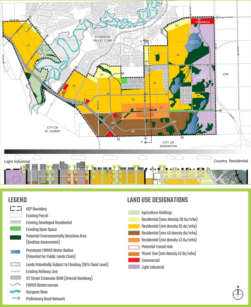
The current area structure plan for the valley dates to 1999. County administration proposed to replace this plan with a new one that would just cover the current built-up or “core” region. Development here would proceed as before, but builders would now have to submit an analysis of the maintenance and replacement cost for any infrastructure built to support new construction.
By 2041, the core would be home to about 6,961 people, up from the current 4,300 or so, with developments not to exceed 20 units per hectare. The core would have protected environmentally sensitive areas such as the river valley, trails that might link to those in St. Albert and the Edmonton Garrison, and a limited number of small businesses and golf courses.
Council also tabled a second area structure plan for the 1,750-hectare “south” region south of the core. This plan was split into five sub-regions subject to future neighbourhood area structure plans, with Areas One (roughly Sturgeon Road to RR 250) and Two (everything between RR 245 and Hwy. 28) being the first to start construction. Area One was to be about 97-per-cent residential, while Area Two was about 89-per-cent light industrial.
By 2041, the south region was projected to host up to 61,152 people at full build-out. The region would have an overall minimum density of 35 units per hectare, falling to 20 as you neared the core region to the north and rising to 42 around a proposed transit hub/mixed-use development at the Twp. Rd. 542/RR 250 intersection. The region would host several commercial nodes/corner stores and a highway commercial site at Sturgeon Road and Hwy. 28, the latter of which could include a library or fire hall. Developers would be encouraged to use of net-zero building, electric car chargers, solar power, and greywater systems throughout the region.
Public hearings on these plans have been scheduled for later this month. Visit www.sturgeoncounty.ca/ourvalley for details.


