
The City of St. Albert's emergency management team has launched a new online map to prepare for emergencies such as evacuations or shelter-in-place scenarios.
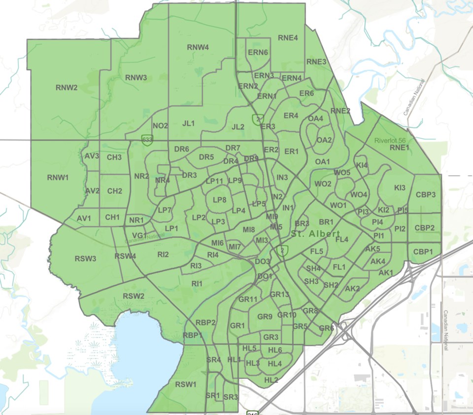
Residents are being asked to familiarize themselves with the map, in which all neighbourhoods and the surrounding rural areas within the city limits are broken up into 153 zones.
The zones are labelled with an abbreviation representing the neighbourhood and assigned a number. For example, Deer Ridge has been split into nine zones, labelled DR1 through DR9.
During emergencies, the city will update the online map and zones will be colour coded, with each colour representing different actions that residents are advised to take.
Currently the entire city is highlighted in green, meaning there are no emergencies. When zones are yellow, it means residents in the applicable zones should shelter in place whether they're at home, work, school, in a business, or in a city facility.
When zones are highlighted in orange, it means residents should prepare to evacuate, and when zones are red, it means evacuate immediately.
The city's manager of emergency management, Mark Pickford, said the zones were set in large part based on major arterial and neighbourhood-level arterial roads to avoid traffic issues, especially for first responders attending scenes.
“There's a tendency when people are evacuating just to get in and drive,” he said. “If we're trying to bring in first responders, and you're trying to get people leaving, we get [jammed] and that causes a whole bunch of further confusion.”
The zones were also delineated to factor for population, as Pickford said another idea behind separating individual neighbourhoods into small zones is that sometimes an emergency will only apply to a small area, such as an individual crescent.
“If you got a phone alert at 3 a.m. saying evacuate Deer Ridge, and we only need to do the part around Doolan Place ... then we're putting potentially thousands of people in panic because they're hearing Deer Ridge, and they're like, ‘Well, I live in Deer Ridge.'”
“We needed to further refine it.”
Pickford said the map has been in development for the past six months, and as part of a new “Know Your Zone” campaign the city is launching next month, in conjunction with Emergency Preparedness Week, residents will receive postcards in the mail detailing what zone they live in, as well as additional information about emergency preparedness.
He also said the city expects there to be a learning curve for residents, especially when or if an emergency happens and the city uses the map to inform those in certain zones of actions they need to take.
“We had talked about leaving it off, like not publishing it, and only putting it out there when we need it,” Pickford said. “[But] we decided that we'll launch it now ... because there is an onus and responsibility of the individual and the families to be prepared.”
“A lot of the time nobody cares until it happens to them, but we felt leaving it open and letting people see it [so] they become familiar and comfortable [with the map].”
Pickford also said the city is working with the province to include the zone system with the Alberta Emergency Alert program, so that when an emergency alert is issued and applicable to St. Albert, it will contain information about which of St. Albert's zones are affected.
The city's system also comes just as the provincial government has begun providing weekly updates on wildfire activity throughout Alberta.
Forestry and Parks Minister Todd Loewen told media on April 18 during the first such update of 2024 wildfire risk and activity is heightened for this time of year.
“To date in 2024 we've had more wildfire starts than we had in 2023,” Loewen said, adding the government has had to learn from last year to be better prepared for the 2024 wildfire season.
“We look at last year, we keep using the word 'unprecedented,' and it was unprecedented, so we had to learn from last year and make sure we made changes for this year,” he said.
“Having not only crews start earlier, we started the wildfire season earlier, and also we made sure we were able to hire more people to make sure we're more prepared.”
As of April 19, the provincial wildfire dashboard shows 48 active wildfires across Alberta, all of which are either deemed under control or being held.
RELATED: Sturgeon County grass fires start three weeks early
The dashboard also says 132 wildfires have already been extinguished this year.
Loewen also asked all Albertans to download the Alberta Wildfire app and to check the online dashboard frequently.


